(Here for State of the Fleet first installment.)
After our gathering in Nome, the east-bound Northwest Passage fleet spread out. Lumi and Damien dashed ahead on spectacular winds, stopping only for a rest at Herschell Island before continuing on and arriving in Cambridge Bay as Mo and crew were departing Elson Lagoon, a separation of some 1,200 miles. At one point, Que Sera was a week in advance of our position, and our western Alaska companions, Pinocchio, passed Mo by as she sat in Elson, her skipper resolving a gearbox issue.
But even a tortoise slowed by breakdowns and a bent for sightseeing will catch runaway hares if the road dead ends, as has happened: the ice just ahead has not yielded. And so what had dispersed is gathering up again at what could be the last ice gate.
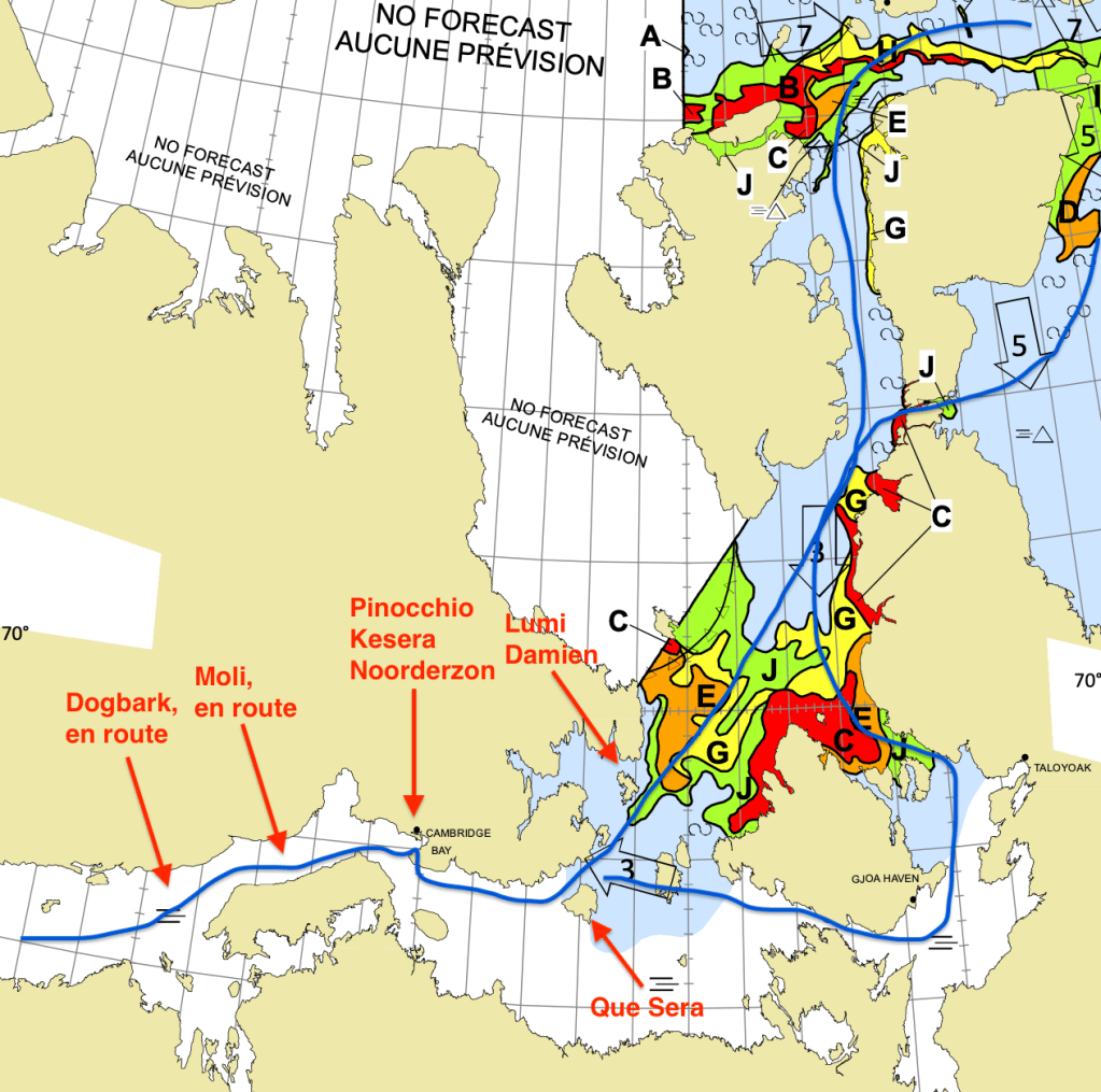
Lumi and Damien hold the most advanced position in a small bay on the north side of Admiralty Island. Que Sera departed Cambridge Bay yesterday and is hold up in Jenny Lind Bay on the southeast side of Jenny Lind Island. Pinocchio, Kesera (a yacht new to me), and the luxury tug Noorderzon are still in Cambridge Bay, where both Moli and Dogbark will arrive in the early morning. Likewise, the westbound fleet is bunching up to the north, in Tay Bay, at Fort Ross, behind Hobday Island.
And why do we wait?
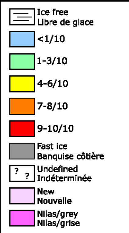
The above image is an ice chart for the Queen Maud region, produced daily by Environment Canada, that shows possible routes through (blue lines, mine) and the ice of various surface concentrations in Victoria Strait and Larson Sound between King William Island and the McClintock Channel. Recall that red represents near total surface cover (9-10/10ths) and light blue nearly none (<1/10th). By way of reminder, here is the legend.
To my knowledge, all the boats approaching from the west are made of steel or aluminum save Dogbark, a 60 foot fiberglass race boat. But even sturdy metal hulls are not ice breakers; we can take contact, even repeated and very hard contact, but we cannot ride over, crush and shove aside the ice that blocks us. We must go around and thus need room to do so. Moreover, the chart is but a snapshot whereas the ice we encounter is always on the move; what the chart says looks possible may have changed by the time of its release.
So then, green we can manage. Green mixed with some yellow is also doable. But what we who have paused see in the left-most route (the route around the backside of King William is at present a non-starter) is that green is blocked by a thick yellow band bordered by orange and red. The red to the east may be stationary, but McClintock channel to the northwest is a feeder, is probably chockablock and could easily push the orange down upon the green and yellow, collapsing it.
In short, the green and yellow middle way looks at moment like a trap. Tempting it is, but so far not one skipper has dared put a foot in. So we wait and hope for a risk-reducing forecast of the morrow. And we remind ourselves that it is still early in the season. Cambridge Bay represents a halfway point for most attempting a Northwest Passage. Arctic Tern on which I crewed in 2014 achieved Cambridge bay from the east on September 4th and still made Nome by September 18th. In 2019, Mo and I arrived Cambridge Bay on August 26th and Nome by September 15th. So we are not wedged between growler and berg just yet.
—
Not quite true, the above. I learned today that Beothuk made it through this plug last night. But she carries aboard a professional ice pilot–and is a steel mega-yacht with several such passages under her keel.

Leave a comment